
DJI Mavic 3T Solution
DJI Mavic 3T
DJI Mavic 3T Enterprise drone. Features include a thermal camera, 56x zoom, RTK module, and a 45-minute flight time. Ideal for search and rescue, firefighting, and reconnaissance operations.
DJIMavic3T
DJI Mavic 3T Enterprise drone. Features include a thermal camera, 56x zoom, RTK module, and a 45-minute flight time. Ideal for search and rescue, firefighting, and reconnaissance operations.

Key Features
PortableandCompact
The DJI Mavic 3T is easily portable thanks to its compact design. Its foldable structure provides operational flexibility, and it's designed with ideal dimensions for quick deployment.
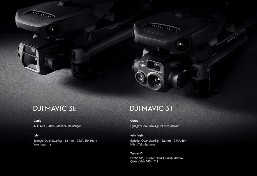
Two Models, Countless Applications
If you want to optimize your business operations, collect reliable data, and increase environmental awareness, the DJI Mavic 3 Enterprise Series is the ideal solution for you.
FocusandFind
Both the DJI Mavic 3 E and DJI Mavic 3 Thermal are equipped with a 12MP Zoom Camera supporting 56× Max. Hybrid Zoom, allowing you to see even the most essential details from a distance. The powerful zoom camera captures high-resolution detail with its 1/2-inch CMOS sensor, enabling detailed inspection and analysis from a safe distance.
Youcanseetheinvisible.
The DJI Mavic 3 T's thermal camera boasts a 640 × 512 resolution. It supports point and area temperature measurement, high-temperature alerts, isotherms, and color palettes to help you make quick decisions and locate your targets. Features include: Precise analysis with point and area temperature measurement; Automatic alert system at critical temperature levels; Color Palettes with 9 different color palettes for visualization options.
SimultaneousSplitScreenZoom
The DJI Mavic 3 T thermal and zoom cameras support 28x continuous side-by-side zoom for easy comparison. This feature allows you to analyze thermal and visible light images simultaneously.
Exceptional Operational Efficiency
The DJI Mavic 3T is a compact thermal-visual drone system designed for emergency response, surveillance, and security operations requiring thermal imaging. It offers superior performance at night and in challenging conditions. Features include: Up to 45 minutes of flight time; Thermal: 640×512 px FLIR Boson sensor + 4× digital zoom; Visual: 48MP + 14× optical zoom + 28× hybrid zoom; Smart features: Spotlight, ActiveTrack, and QuickTransfer; AES-256 encryption; and IP43 water resistance.
Multi-faceted sensing for safe flight.
Equipped with wide-angle lenses on all sides to avoid obstacles in multiple directions with zero blind spots. You can adjust braking distance and proximity alarms depending on mission requirements. It saves power and time by automatically planning the optimal route home. Advanced Pilot Assistance Systems provide automatic reorientation around obstacles. Safe flight with zero blind spots thanks to wide-angle lenses in every direction.
Intelligent Task Features
Thanks to Mavic 3 E's multi-directional sensing capability, you can automatically adjust the altitude when mapping areas with elevation differences without needing to import external altitude data. Smart Oblique Capture increases the efficiency of your oblique photography tasks. The gimbal automatically rotates in three directions: front, center, and rear. It collects all photos at the angles required for high-precision 3D modeling. You can record mission actions such as aircraft movement, gimbal orientation, photo capture, and zoom level to create sample mission files for future automated flights. With Corridor Mission Planning, you can create automated flight missions for highways, rivers, oil pipelines, and more. Simply draw a line on the map.
DJI TERRA
DJI Terra is a 3D modeling software based on photogrammetry technology. Using DJI LiDAR, it supports accurate and efficient 2D and 3D reconstruction of various visible light and data. Realistic 3D models can be created in three different resolutions. Water surfaces are automatically optimized using artificial intelligence technology. With a single click, DJI Terra enables high-accuracy processing of point cloud data captured by Zenmuse LiDAR. Multispectral data from the DJI Mavic 3 Multispectral provides insights into plant growth and health.
Accessories
Advanced features for professional operations; RTK module for centimeter-level accuracy; Mobile RTK base station solution; Voice system for search and rescue operations.
Professional Operations with DJI Mavic 3T and Bi-Defense Assurance
Optimize your search and rescue, firefighting, and investigation operations with thermal imaging, advanced zoom, and intelligent mission features. Our expert team is ready to provide you with the best possible solution.
GetaQuote
Contact our team for detailed information and a tailored enterprise quote for DJI Mavic 3T and our other solutions.